Introduction
The best Algarve photography locations are concentrated along Portugal’s southern coast. You have likely seen some of these places numerous times in travel blogs and on Instagram, and yet standing on the edge of a limestone cliff at golden hour with the Atlantic blazing orange below you — it is still awe inspiring. Towering sea stacks, hidden coves, natural arches carved over millennia, liter the coastline and what drew me to this location.
The Algarve stretches roughly 155 kilometres along Portugal’s southernmost coast, from the Spanish border in the east to Cabo de São Vicente in the west. The stretch between Lagos and Albufeira — sometimes called the Costa de Ouro, or Golden Coast — is where the most dramatic coastal photography is concentrated. Limestone cliffs of deep amber and rust, sculpted by Atlantic swells into arches, grottos, and isolated sea stacks, with turquoise water so clear it almost looks artificial.
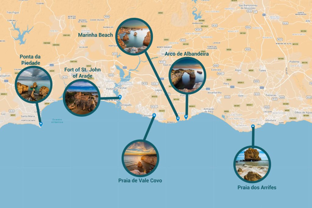
We based ourselves in Carvoeiro, a charming fishing village that sits almost exactly at the centre of this stretch, putting every location in this guide within 45 minutes.
There are other stunning locations in the Algarve — Benagil Cave, Praia do Camilo, Praia da Falésia — but the locations below are the ones I personally photographed, and in my opinion represent the most iconic and diverse coastal photography the region has to offer. Each one is distinct. Each one is worth setting your alarm for!
Map Locations
Praia da Marinha (Marinha Beach)
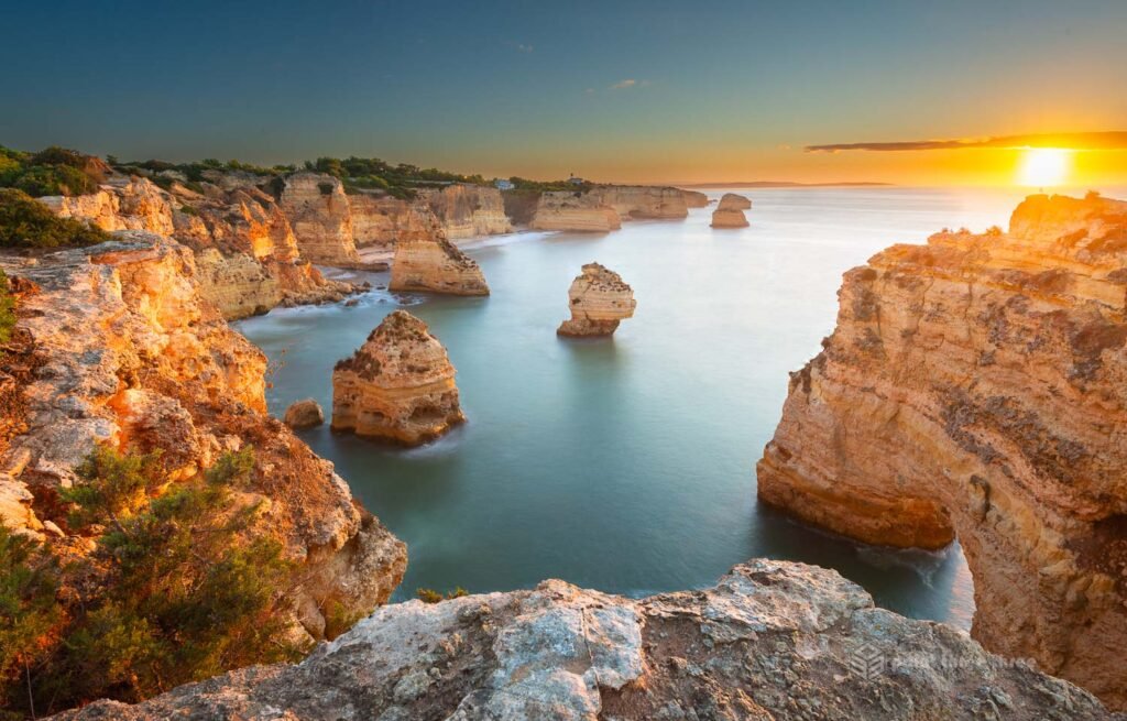
Photo GPS Location: 37.088214, -8.415962
Camera details: Nikon D800E, 16-35mm @ 18mm, f11 (6 stop ND filter for water exposure)
Praia da Marinha is consistently ranked among the most beautiful beaches in all of Europe, and standing above it on the clifftop trail, it is not hard to understand why. This was my number one “must-have” locations on our Algarve trip.
We had 6 nights in the Algarve and anchored our trip with a bit of splurg staying at the Tivoli hotel in Carvoeiro. That gave me time to scout this location. This composition is very much a sunrise shot. I did not want to be scouting in the dark before sunrise and luckily figured it out the evening before!
I knew roughly where to compose the shot, but could not find information on the best way to get to the GPS location (see above). Studying google maps I ventured down a sketchy dirt road to the west of it, followed by a precarious hike. Dumb mistake, don’t do this, park at the beach parking lot and do the super simple hike west.
You will be rewarded with golden limestone cliffs that drop into turquoise water, framed by a series of natural arches, sea stacks, and rocky outcrops that make almost every composition a strong one. It is a technically challenging shot that will require a tripod, wide angle lens and ND filter. The ND filter will help to enable a 10+ second exposure to blur the water. Multiple exposures to then hold the sun, sky and foreground rock together.
Its a shot that has been done many times, but I’m very happy with how my version turned out.
My gallery post of this image is here.
Arcos Naturais – “O Coração do Algarve” (Heart of the Algarve)
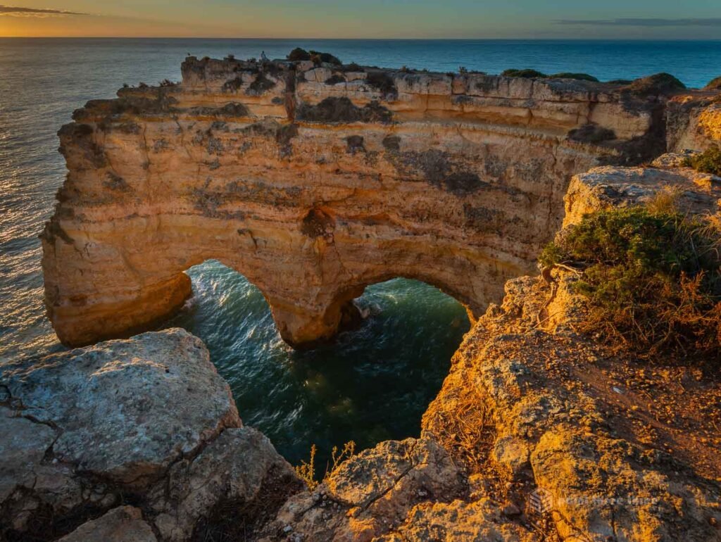
Photo GPS Location: 37.088495, -8.415794
Camera details: Nikon D800E, 16-35mm @ 18mm, f11
This location is just metres from the Praia da Marinha image above! Its deserving of its own entry entirely so counting it as one of the five. The Arcos Naturais is a double sea arch at the western edge of the beach that has become one of the most photographed natural features in southern Portugal. From a specific angle along the main clifftop pathway, the gap between the two arches frames a near-perfect heart shape — known locally as O Coração do Algarve, the Heart of the Algarve.
As with the other photos in this blog, you will need to be close to the edge to get the proper framing so keep focused and stay safe.
This is a sunrise location as well. I composed this image, minutes after my Praia da Marinha image!
The heart shape catches the early morning light beautifully, and you will have the added benefit of far fewer people on the path. By mid-morning in summer, the viewpoint can become very busy. The GPS coordinates above will bring you to within a short walk of the viewpoint along the clifftop trail.
Praia dos Arrifes
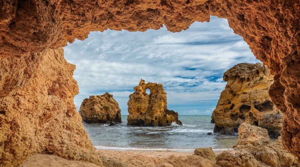
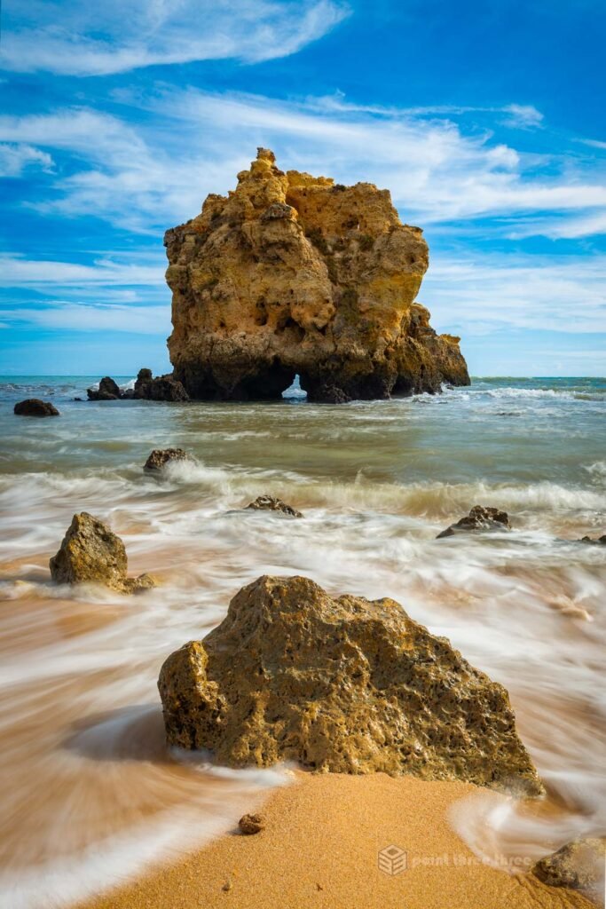
Photo GPS Location: 37.076062, -8.277495
Camera details: [Add your camera details]
Praia dos Arrifes — also known locally as Praia dos Três Penecos (Beach of the Three Rocks) — is one of the smallest beachs in Albufeira, but I think its the most dramatic. Three great sea stacks rise from the water directly in front of the beach, creating one of the most distinctive and graphic coastal compositions in the entire Algarve.
This location is ideally shot at sunrise. There are nice compositional angles facing east that will have the sun rise behind the stacks. Alas, sunrise was not an option for my itinerary so I worked with what we had.
The beach is tiny — only about 75 metres of sand — and sheltered by low pine-covered cliffs that give it a tucked-away, almost secret quality despite being just a few kilometres from central Albufeira. At low tide the beach expands and rock pools appear around the base of the stacks, giving you foreground interest that is hard to beat for long exposure work.
There is an unpaved parking area at the top of the cliffs. Access to the beach is via a wooden staircase — short but steep.
An added bonus, there is a nice restaurant right on the beach that we took advantage after exploring various compositions at this wonderful location.
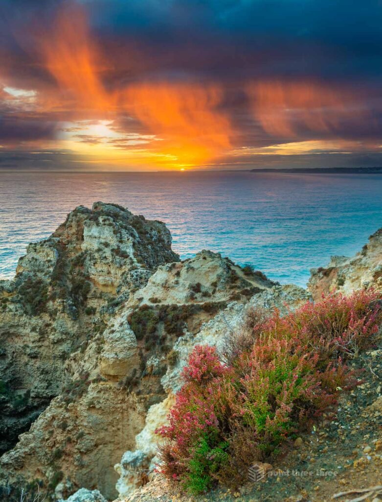
Arco de Albandeira
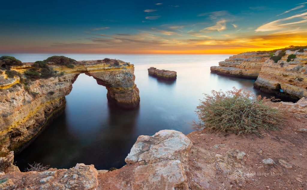
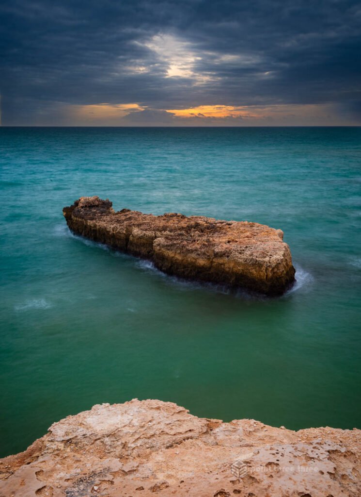
Photo GPS Location: 37.090758, -8.400788
Camera details: Nikon D800E, 16-35mm @ 17mm, f16, ND filter
The Arco de Albandeira is one of the most impressive natural arches on the Algarve coast — a massive limestone sea arch that separates Praia de Albandeira from the neighbouring hidden cove of Praia da Estaquinha. It is often referred to as a “pirates’ cove” or “smugglers’ cove”. While less famous than the Heart of the Algarve or Ponta da Piedade, many photographers who have visited all three consider the Arco de Albandeira to be the single most photogenic arch in the region for its sheer scale and drama. I would very much agree.
This location can be both a sunrise and sunset location. I composed the above images on two different evenings at sunset. The second one as mentioned in the description is taken from the top of the arch area. Give yourself enough time at the location to explore and make your own unique composition.
My gallery post of this amazing arch can be seen here.
Ponta da Piedade
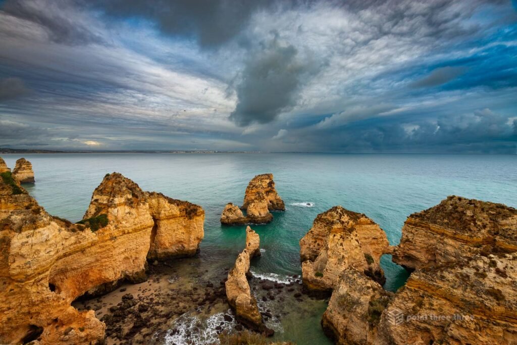
Photo GPS Location: 37.079847, -8.668711
Camera details: Nikon D800E, 16-35mm @ 16mm, f8
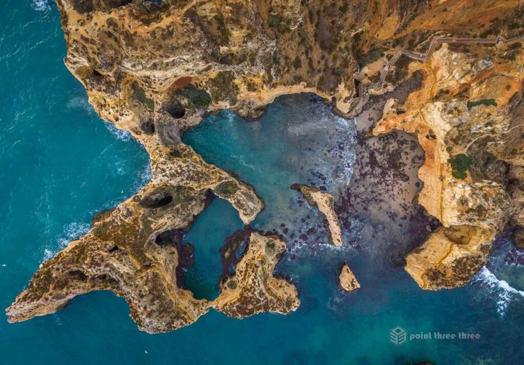
Ponta da Piedade, just south of Lagos, is the most iconic photography location in the entire Algarve. A dramatic headland where towering golden limestone pillars, carved by the sea into a labyrinth of arches, grottos, sea caves, and narrow passageways. Some of the formations have been named by local fishermen over generations: the Elephant, the Cathedral, the Sphinx, the Titanic.
There are several ways to photograph Ponta da Piedade. The iconic image you see mostly online is down at sea level during sunrise. The most iconic cliffs will be facing out to the east/ southeast. Mother nature and itinerary constrained my sunrise options here. But if you can, from the clifftop, a series of wooden walkways and staircases lead down to a lower terrace with extraordinary views across the rock formations to the sea.
That being said, this is such an amazing location, you can come home with great compositions at other times and atmospheric conditions. We had a storm come through when I was on location, and sometimes if you are lucky, that results in an amazing light show during golden hour. The result was the third image above.
If you have a drone, this is truly an amazing coastline to explore various compositions from above. Just be aware of the coastal birds, they were constantly testing and dive bombing my DJI drone!
Bonus Locations
Forte de São João do Arade (Fort of St. John of Arade)
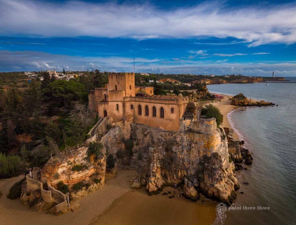
Photo GPS Location: 37.119597, -8.522558
Camera details: DJI Mini 5 Pro
Forte de São João do Arade is one of the lesser-known photography locations in this guide. This 17th-century Portuguese coastal fort guards the mouth of the Rio Arade estuary near Ferragudo. It is a remarkably photogenic structure: compact, well-preserved.
The fort is not open to the public, but it is visible and highly photogenic from the beach and river. My favourite composition from the location was actually from my drones vantage point.
Praia de Vale Covo
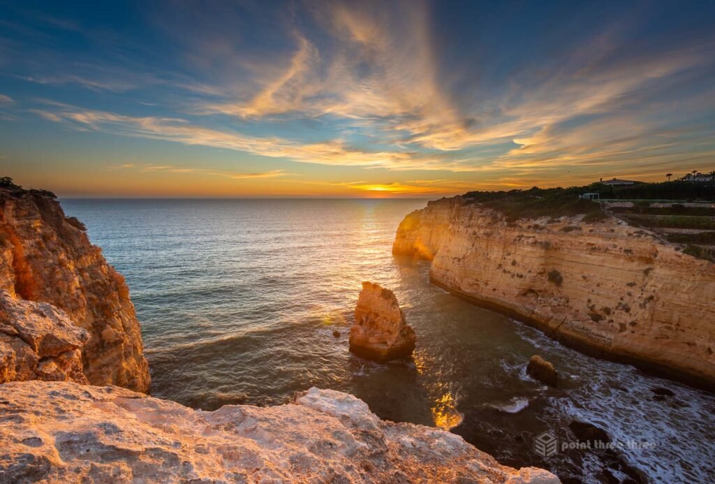
Photo GPS Location: 37.092751, -8.459445
Camera details: Nikon D800E, 16-35mm @ 16mm, f8
Praia de Vale Covo is the hidden gem of this guide. A small, secluded cove tucked between towering cliffs just east of Carvoeiro and directly below the Tivoli Carvoeiro resort. We stayed at the Tivoli and enjoyed this view all week!
A lone sea stack rises from the water in the centre of the cove, which I believe the locals refer to as “pig rock”, framed on one side by a massive natural arch cut into the eastern cliff, and on the other by the golden limestone headland stretching west toward Carvoeiro. At sunset, the whole scene is bathed in extraordinary warm light.
The photograph was taken from the clifftop above the cove — a viewpoint that gives you a sweeping panoramic composition looking west over the sea stack toward the setting sun. The clifftop viewpoint is reached via the Carvoeiro boardwalk past Algar Seco, continuing east on the cliff path to the Tivoli Carvoeiro. It is a little bit of a scramble to get up the cliffside to this location, but nothing that is overly scary or demanding.
Why is Benagil Cave not on the list?
Benegil Cave is one of the most popular and iconic locations in the Algarve. You will see posters and tours for this location. I very much wanted to photograph this location too. Unfortunately, they now have restrictions, likely a result of over tourism on the location. The iconic compositions are taken from within the cave on the beach and as of August 2024 you are no longer allowed to do that. You can still take smaller boats inside the cave, and while still an amazing site, I chose to pass.
Some Useful Links
Tide Information
• Tideschart.com – This will be especially useful at Praia dos Arrifes. But also any of the locations which compositions can be altered by low or high tide.
Trail Information
• Wikiloc or the official Rota Vicentina site for hiking and trail information.
Golden Hour / Sun Position
• PhotoPills or The Photographer’s Ephemeris are indispensable tools for the landscape photographer in planning your sunrise and sunset compositions.
Official Tourism
• Visit Algarve — the official regional tourism site.
Conclusion
The Algarve coastline is one of the most photographically rich stretches of coastline in Europe. These locations represent what I consider the most iconic and diverse shots the region has to offer. Each one rewards the early alarm, the low tide check, and the willingness to explore a little beyond the main path.
Based in Carvoeiro, all locations are within a comfortable drive. If you are planning a family and/or photography trip to the Algarve, I cannot recommend this region enough. We will certainly be back.
Let me know if you have other recommendations in the comments below.
Planning another European photography trip? See our 12-day Italy photography itinerary.