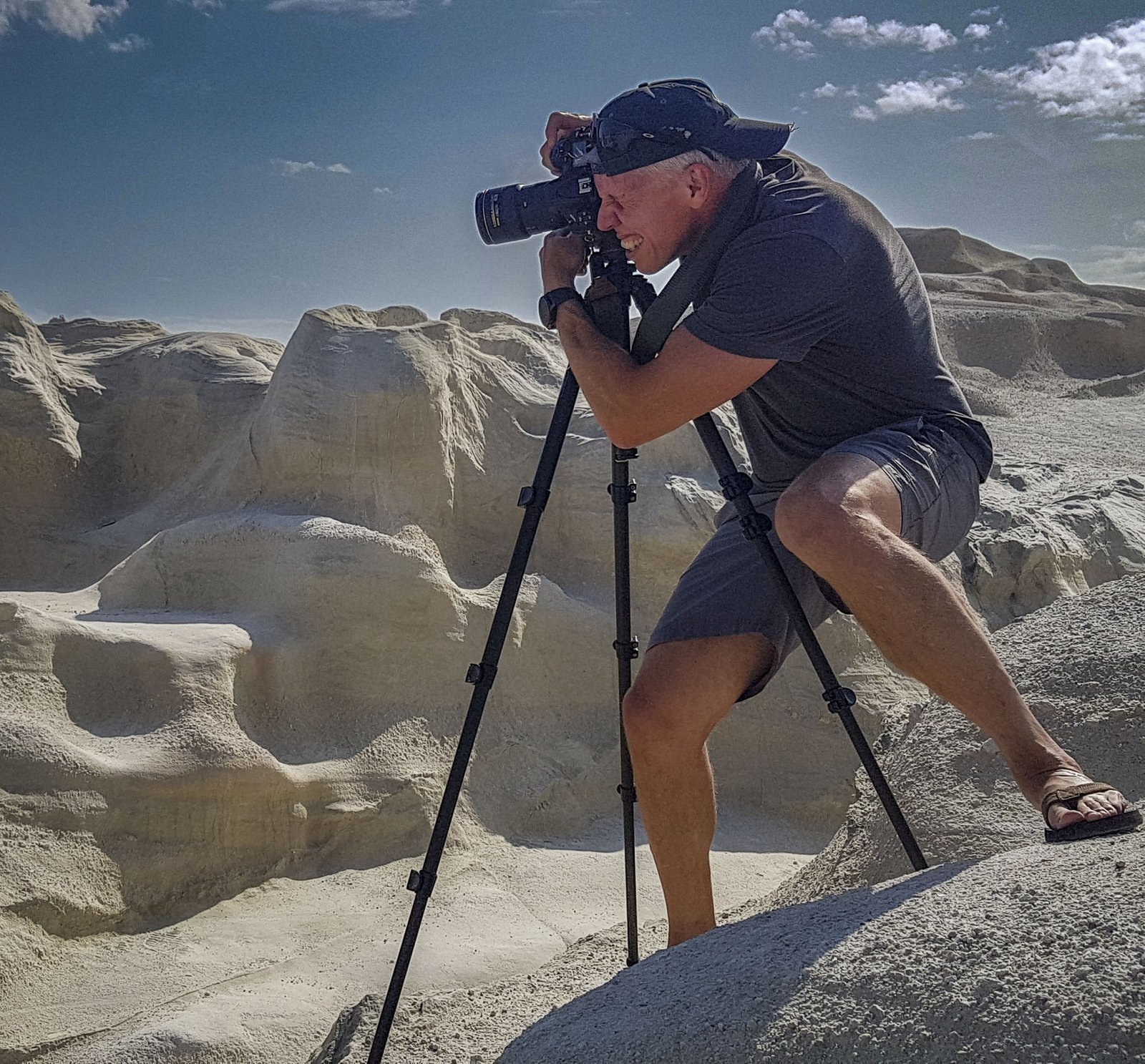
Tuscany Photography Locations – Planning Your Trip
The best Tuscany photography locations are concentrated in the Val d’Orcia region. Rolling hills, cypress-lined roads, stone farmhouses, and medieval hilltop towns that have barely changed in centuries. It’s a landscape that has been painted, photographed, and written about and standing in the middle of it at sunrise, you understand why. Tuscany’s official tourism site is here.
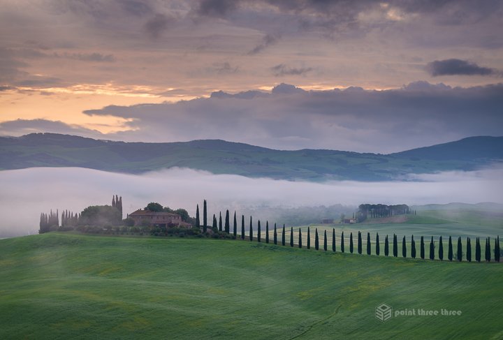
At the heart of it lies the Val d’Orcia — a wide valley in southern Tuscany that UNESCO declared a World Heritage Site in 2004, recognizing it as one of the most iconic agricultural landscapes ever shaped. Stretching roughly from Montalcino in the west to Monte Amiata in the east, the valley is defined by its undulating clay hills, geometric patterns of plowed fields, solitary farmhouses framed by tall cypress’s, and a quality of light that photographers travel from across the world to capture.
Late spring, when I took these photos, the valley is a vivid green, with wildflowers dotting the hillsides and morning mist pooling in the low valleys before the sun burns it off — arguably the best season to visit. That being said, I think this region is beautiful year round.
These 6 locations were curated as part of longer Italy trip that took our family from Milan to Rome. You can review that blog post here. We based ourselves in San Quirico, as its roughly 30 minutes to any one of these locations. More on that location in the aforementioned blog.
There are other amazing locations in Tuscany. Too many for me to cover in 3 days, which we had budgeted in our itinerary. You might be thinking, what about Florence, Pisa, Siena etc? They are superb locations, and I have amazing “cityscapes” from there on prior trips, but the locations recommended below are more inline what I think of when imagining a Tuscan landscape.
In short, I think these are the most iconic in the region — each one distinct, each one worth setting your alarm for.
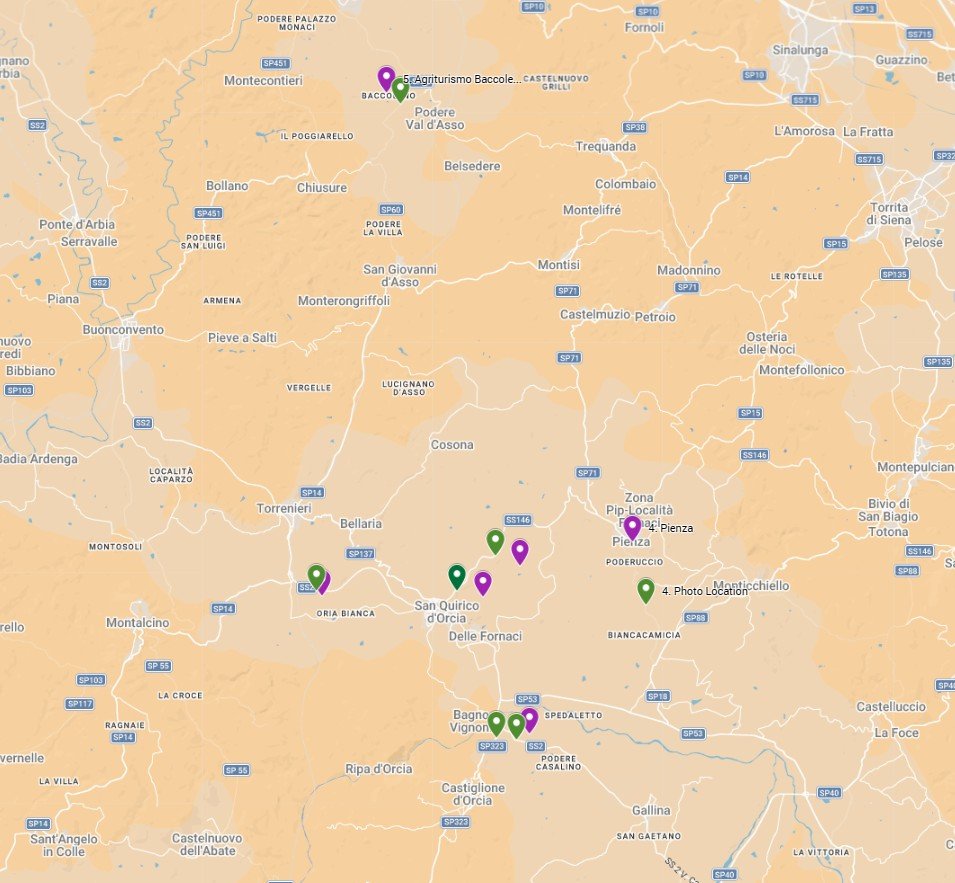
Map Locations
Cipressi di San Quirico d’Orcia
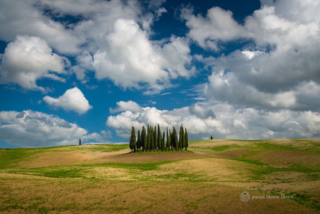
Photo GPS Location : 43.0639, 11.55698
Camera details : Nikon D800E, 24-120mm @ 40mm, f8
I had long seen images of this location, and it was at the top of my bucket list in the region. Alas, the field had already been plowed and iconic green was no longer there. Regardless, I was still very pleased with the composition and imgage. This is one of those rare landscape locations that can still be amazing anytime of the day. I typically target golden hour, sunrise or sunset, but this was a mid-afternoon shot.
Parking at this location can be a challenge. There are only spots for a couple vehicles right on the side of SS2 where the dirt road leads to the grove. I witness several close calls with ignorant tourists, so be very careful as you trucks and cars traveling at speed on this road.
The location I shot from was almost literally under the overpass. I walked along the property line. Be respectful! This is private land. Of course I saw several selfie taking tourists wandering through the farmers field so they could get their Instagram pic. You wonder why the locals get agitated.
You can explore various compositions from the bottom of the hill below the cypress and try various camera focal lengths to get “your” version of this iconic image.
My photo gallery post of this image can be viewed here.
Poggio Covili
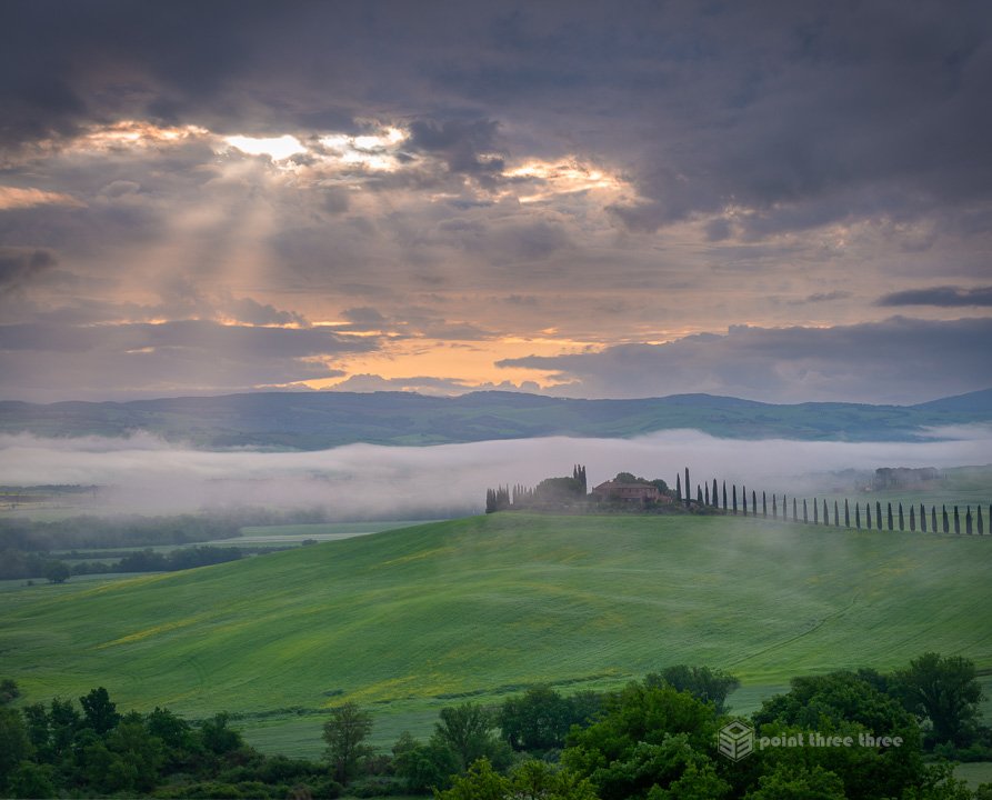
Photo GPS Location : 43.02292, 11.62576
Camera details : Nikon D800E, 70-300mm @ 70mm, f8
Poggio Covili is an amazing location. Most people probably know this location from Instagram selfies and models standing between a long straight line of cypress trees leading to the farmhouse. While I snapped that image as well, I think other viewpoints of this location provided here, are much stronger landscape compositions.
This is definitely a sunrise opportunity, so set your alarm! This composition was probably 45min after sunrise and still had the morning mist and fog, but the rays of sunlight peaking through the clouds added that little extra for me. You will want to pack your medium telephoto lens as you are shooting a fair distance down into the valley and will want to isolate the subject a bit.
To get there, as you head up SP323 toward Castiglione d’Orcia, you will find a small pullout close to the GPS location provided above. There might be a couple fellow photographers there as it’s a fairly popular location.
Poggio Covili -The Cypress Lined Road
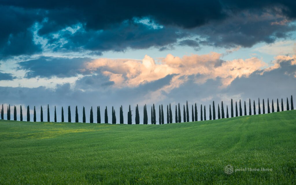
Photo GPS Location : 43.02237, 11.63313
Camera details : Nikon D800E, 24-120mm @ 82mm, f8
This location is just down the road from the entrance to the farmhouse. And likely where others are parked to take their selfies. I felt it was a strong graphical composition with just the green grasses, cypress trees and dramatic sky at sunset.
I targeted the location close to sunset. That being said, its not that light on the hill or tree’s were relevant, it was the dramatic clouds that caught that golden hour light which I felt was an important adder to the composition.
You can try various focal lengths from wide to medium telephoto to get your own version of this iconic location.
Podere Belvedere
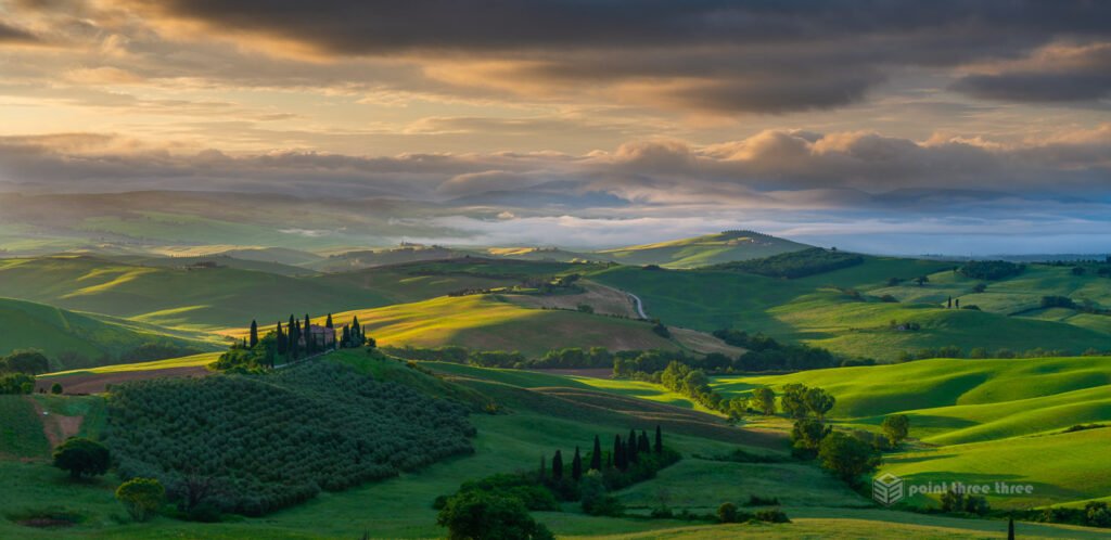
Photo GPS Location : 43.0638, 11.61055
Camera details : Nikon D800E, 24-120mm @ 55mm, f8
This is probably my favourite image from Val D’Orcia. Often called the most photographed farmhouse in all of Italy, this stone house surrounded by cypress trees sits just outside San Quirico d’Orcia on the SP146 toward Pienza. When leaving San Quirico for Pienza, the spot is after about 100-200 meters on your right. Leave your car 100 meters further down the road at a parking place, walk back, then go about 20 meters down into the valley — you’ll see the footprints of everyone who has shot this spot. This is on private land so be respectful!
This is most definitely a sunrise location and you will want to be there before the sun peaks across the horizon. There was probably 15 other photographers as part of photo tour when I was there. If you are lucky, there will be mist and fog in the lower valley and as the sun rises, it will light up the green rolling hills providing an amazing depth to the scene.
Photo tip : in the spring, the sun will be rising at a sharp angle to your lens so be very careful of lens flare!
This is a good example of when to use a photography app when planning your shoot. I use Photo Ephemeris but Photo Pills is probably the most widely used.
Pienza
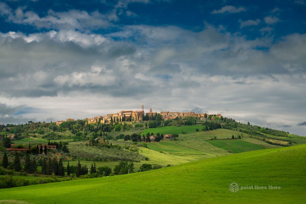
Photo GPS Location : 43.06003, 11.6826
Camera details : Nikon D800E, 24-120mm @ 75mm, f8
Pienza is a UNESCO-listed hill town and one of the finest Renaissance villages in Italy. While this photo is of the town, I highly recommend exploring Pienza. Beyond it being a wonderful down that we spent the day in, there are many compositions you can take of the buildings and alley ways but also looks back over the valley below.
The photo location is a couple km’s south of the town at the above gps coordinates. You will be driving north on SP18 and the scene will present the hilltop town beautifully against the valley. There are several areas to pullout which I used and this was snapped from the side of the road.
Golden hour light would be ideal, but my itinerary didn’t enable that planning. I was lucky to have some nice clouds and sun that provided some added depth to the beautiful rolling grass hills.
You will want a medium telephoto and experiment with various focal lengths to get your preferred composition. At 75mm I felt it provided just the right amount of compression and still wide enough to capture a full landscape of the town.
Agriturismo Baccoleno, Asciano – Warning!
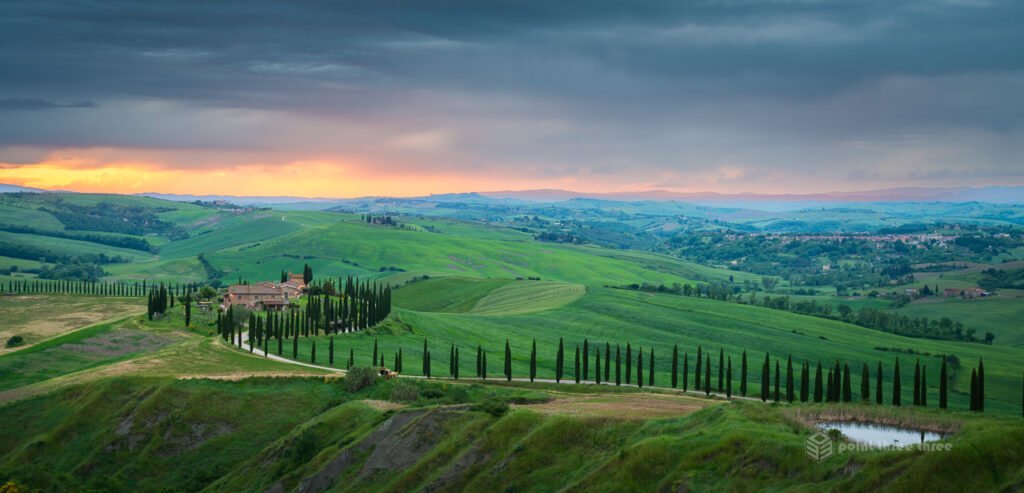
Photo GPS Location : 43.19931, 11.589
Camera details : Nikon D800E, 24-120mm @ 48mm, f8
Located in the Crete Senesi region (technically just north of Val d’Orcia), the winding cypress-lined road of Baccoleno is one of Tuscany’s most iconic images.
WARNING: the classic shot you have seen all over the internet is now restricted! I am guessing the owners finally had enough of tourists abusing and encroaching their land. There is a pullout just up the road from the property that is fenced in. There are also signs banning flying of drones.
My composition is taken from the viewing area provided. The composition is not nearly as strong but still a wonderful view. It was about a 30min drive from Castiglione d’Orcia where we were staying. I will let you make your own decision whether its worth the drive now versus some other locations.
This image was taken at sunset. I was lucky to get some moody atmosphere. It was raining lightly at the time but I have found that sometimes can produce magical lighting at golden hour. It’s a tricky exposure as its backlit so you will need to take several exposures and blend them later to get the dynamic range.
Chapel of Madonna di Vitaleta
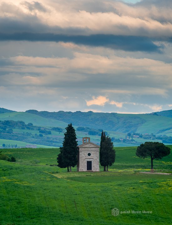
Photo GPS Location : 43.07358, 11.62522
Camera details : Nikon D800E, 70-300mm @ 300mm, f8
This tiny 17th-century chapel perched between two cypress trees is one of the most beloved subjects in all of Tuscany. It sits on a hill between San Quirico d’Orcia and Pienza, off Strada Provinciale 146 (SP146).
This image was taken from SP146 and there is pullout areas that are pretty noticeable. Depending on the time of day, you are likely to see other tourists parked along the road too. I would have preferred to take this at golden hour, but that was not an option for our itinerary.
Its about 800m from the road to the chapel so you will need a telephoto if you want the chapel to fill more of your composition. That will have the benefit of nicely compressing the scene with the hills in the background.
Conclusion
While there are certainly other amazing locations in the Val D’Orcia region, these were the iconic spots I focused on during my 3 days in staying in Castiglione d’Orcia. For more details on the that and how this fit as part of an amazing 12 day Italian itinerary from Milan, Cinque Terre, Bologna and Rome, click here. I can’t recommend this region enough, and we will certainly be visiting again!
Let me know if you have other recommendations in the comments below.